

What do you need?
Destination
Category


experiences
Guided tour of Chícamo River
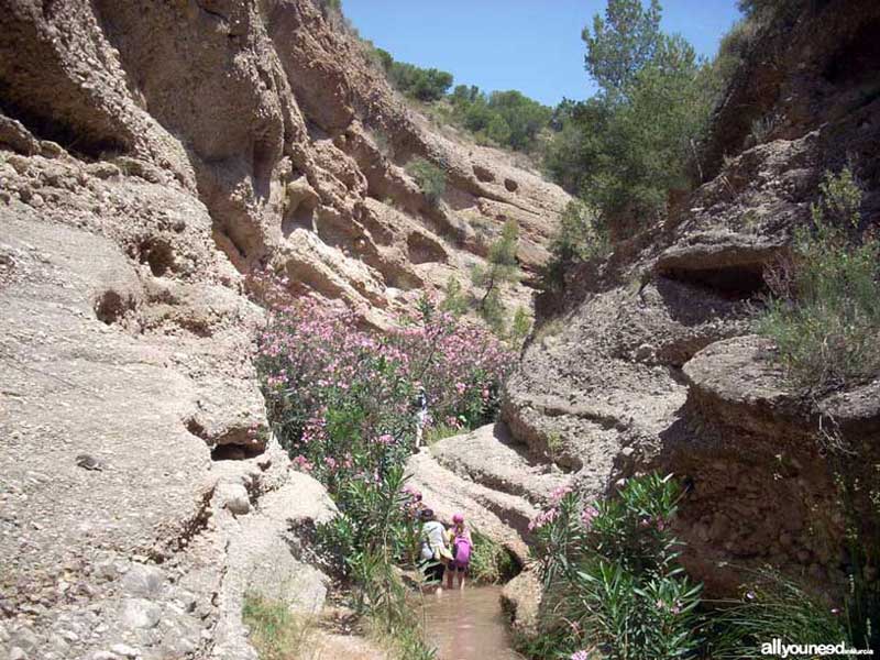
This area of astonishing beauty and interest, both geological and biological, starts in the district of Macisvenda, in Abanilla. The river is part of a large network of wetlands and ravines, such as Mascosa and Zurca, which supply constant water flow to this river.
It is simply fantastic to walk along the ravines of a delta shaped over 10 million years, when this area was under the waters of the Mediterranean sea.
In terms of vegetation, oleanders, salt marsh plants, thyme and date palm trees, among other endemic species, are the most common, whereas in terms of fauna, the most distinctive living creatures are the fartets, fish in danger of extinction that only lives in this particular place.
This path can be easily walked, combining arid landscapes (badlands) with a beautiful canyon where it is necessary to walk in the river as sometimes there is no other possibility. This happens in the last 500 meters of the trail, when it is necessary to cross a road near Umbría where there are signs indicating the direction and distance to Mahoya, Partidor and Cager. We highly recommend this trail, even in the company of children (they will have a blast!).
Trail length is 8.2 kilometers one way. The starting point is the Santa Cruz Chapel in Mahoya and the finish point is in Cager. You can shorten the trail by parking your car in Partidor or walk the trail only in one direction if there is a designated driver picking everybody up.
The Chícamo River runs parallel to this nature trail most of the time.
Guided tour of Chícamo River. Also known as Nature Trail Mahoya - El Cager PR-MU 74
Organized by the information and tourism office of Abanilla
The starting point is the Santa Cruz Chapel in Mahoya and the finish point is in Cager, for a total distance of 8.2 kilometers. We did not complete the trail.
- Starting point. The group got together in the gas station outside Abanilla (picture “0”) .
- We began the trail (direction Murcia) and in the first roundabout, took the road to Yecla, Mahoya direction. We did not start the route from the starting point; instead, we drove to Partidor and then parked the car in an esplanade by the road, next to Bar de Pepe (picture 1). When we came back, we stopped at the bar to enjoy a few cold beers. Parking the car in this area shortened the trail some three kilometers. All the drivers came back to get the cars and then went to Umbría (end of the trail) to park most of the cars so that the 8.2-kilometer trail did not have to be walked in both directions. We parked on the side of the road next to a sign indicating the distance to Cager, Partidor and Mahoya (pictures 2 and 3). Once on the way to Cager, the Canyon is very near (500 meters). This is where the trail ends. We came back in 3 full cars to Partidor, were we started the route with the tour guides and the company of two civil protection volunteers at all times, for safety purposes.
- El Partidor (pictures 4-7) is where Chícamo River waters split before being channeled to the irrigation ditches.
- Roman bridge (pictures 8-10)
- Before lunch (pictures 11-13). The place where we ate was an oasis surrounded by trees, water, and capes.
- Lunch (pictures 14-17)
- Before crossing the canyon (pictures 18-20), we walked through some moonlike landscape “Bad Lands” and crossed the river a few times. There was a variety of landscapes
- In the canyon (pictures 21-27) There are some sections where you need to get wet because the only path is through the river. But don't worry because the water only goes up to your ankle...although having said that, I got water up to my knee after sticking my leg in a hole.


0
comments

 Downloads
 Related links


