

What do you need?
Destination
Category


Sports & Adventure
Portazgo Castle Route; PR-MU54
Spanish name: Ruta Castillo Portazgo PR-MU54
Hiking in El Valle
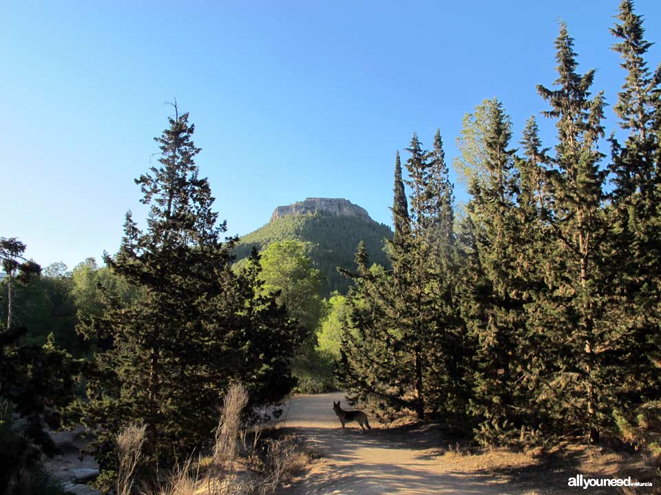
This easy route, just 15 minutes from Murcia, starts at the Portazgo castle, leading through a pathway to the high area where the ruins of the Asomada castle are found. .
At the beginning of the pathway, marked with white and yellow signs, in the Cadena Mountain Pass there are puddles with varying amounts of water, depending on the season. The Cadena Mountain Pass ravine basin has a surface area of 26.7 km2 and fresh water flows pretty much all year round, favoring the presence of vegetation that is typical in this type of places such as oleanders, glazing beads and many different types of reeds, among others.
Before getting to the Pass ravine, you will go through a pine tree area. To continue, cross the Pass ravine and you will find a large number of water puddles that have water most of the year. After leaving the ravine behind, you will get to a little creek with some tree trunks laid horizontally to help people cross, a sign indicating the way to the castle and typical trekking route signs. From that point onwards, the trail gets steeper so you may have to stop occasionally.
After some 30 minutes walking, the trail splits. Take the path on your left (the one on your right goes to Majal Blanco) and shortly after you will find a steep slope on your right, next to a pine tree and some marks on a large rock indicating you are on the right trail. In any case, if you don't take the right trail and continue straight you eventually get to the Asomada castle, although it will take longer.
After the steep slope there is a shelf known as “Collado Mosqueras” where you can rest and enjoy the views of the Cartagena countryside. Finally, the way to the castle will be on your left through a rocky slope with no pathway, so be careful! If you go up, you will eventually see the castle ruins, from where there are views of the freeway, the Murcian orchards and the mountains around them. Good place to take pictures.
You can walk back on the same route, although it is more fun to do the full circle, which means you have to follow the trail right before the last slope to the castle. That unmarked trail will take you to a power tower, where you have to take a left (coinciding with the longer route mentioned earlier) This trail runs parallel to the freeway, so you can take alternative routes that are a bit quieter. Right before getting to the Portazgo castle you will find a large tube going across the freeway. Cross it and you will see a fence (open it) and stairs taking you straight to the other part of the Portazgo castle, which is some 200 meters from the tube crossing over the freeway. To access directly from the parking area, take the trail between the freeway and the castle; you can't miss it.
Visit document Castles of Asomada and Portazgo if you wish to know the history of both castles
Getting there
A-30 highway from Murcia to Cartagena; take the 150 exit towards Nonduermas and Paloma; follow indications for the castle and leave the car in the parking lot. From Cartagena to Murcia Tke the 150 exit towards El Palmar
Although there are indications to get here, keep in mind two things:
- When you walk pass the tree trunks, take the path on your right to avoid getting wet (picture 9).
- Later, if you want to avoid the long route and the freeway noise, take the steep route next to the pine tree (picture 12).
Route features::
Start and end : Casas del Portazo-recreational area Route: Linear
Distance: 5 km , both ways Duration: 2h Difficulty: Easy Inclination: 340m
Itinerary: Casas del Portazgo-recreational area,Fuente del Caño, Rambla del Puerto, senda de la Umbría, Collado Mosqueras (link PR-MU23), Castillo de la Asomada (S-XII) o cumbre del Puerto.
Circular route:
Distance: 7,57km Duration: 2h, 40m Difficulty: Easy Inclination: 340m


0
comments

 Downloads
 Related links