

What do you need?
Destination
Category


Destination
La Manga del Mar Menor
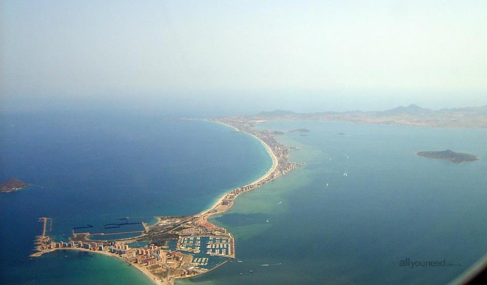 La Manga del Mar Menor, 20+ kilometer strip of land separating the Mediterranean Sea from the Mar Menor Salt Lake, from the town of Cabo de Palos (lighthouse) to Las Salinas, in San Pedro del Pinatar. La Manga, with a width ranging from 100 to 1,200 meters, connects with Mar Menor through channels called "golas", where both bodies of water meet. The central gola (called El Estacio) connecting to the marina, and the Marchamalo gola (to the North), were both widened to favor access. The Ventorrillo and El Charco golas in the weir area, are both natural.
There are a number of volcanic islands on both sides of La Manga: La Perdiguera, Isla Mayor (also known as Isla del Barón), Isla del Ciervo, Isla del Sujeto and Isla Redonda (or Rondella) in the Mar Menor Salt Lake, and Isla Grosa, Islas Hormigas and Islote Farallón in the Mediterranean Sea.
Presence of human activity dates back to the Neolithic period. It is also known than both Fenicians and Romans used the El Estacio gola as a berth. The first weirs were built in the Middle Ages. During the reigns of Carlos V and Felipe II, coastal watch towers (El Estacio, La Encañizada and Pinatar) were built to protect the area from the Berbers.
La Manga was urbanized in the mid-20th century, establishing itself as one of the main tourist destinations in the Region of Murcia. La Manga is managed by the municipalities of Cartagena (South area), San Javier (North areas).
See all the beaches in Murcia
See Destinos on a large map


 Downloads
 Related links