

What do you need?
Destination
Category


Sports & Adventure
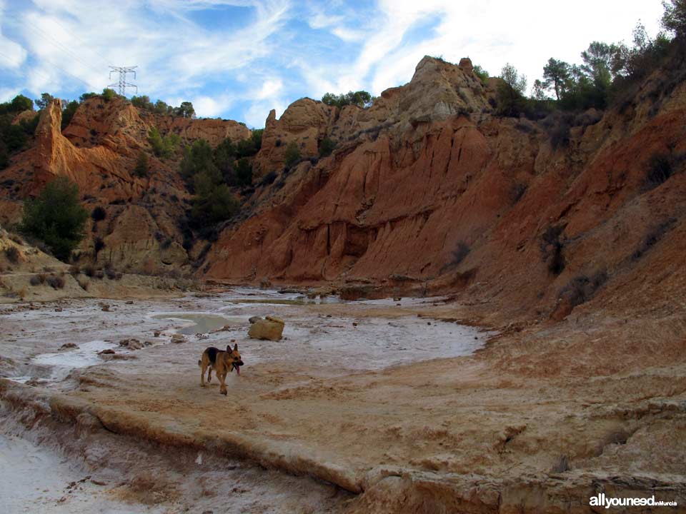
Hell Ravine
Rambla de Librilla
30892 -Librilla-
Spanish name: Barranco del Infierno
 This easy trail in mostly flat terrain has a length of 8 kilometers (return) We do not recommend walking this trail in the summer as there is only shade in the pine tree area and in the last part of the ravine.
To get to the starting point, go to Librilla on the A7 (from Murcia to Lorca) and before getting to the city center, take the C2 towards Fuente Librilla. After 2.4 kilometers you get to the Tagus-Segura Diversion; once there, park your car.
The route starts taking the diversion service road to Sifón de Librilla. Before getting to the bridge, you need to go down a steep path towards the ravine; diversion pipes will be on your left. At that point, you are in the ravine (pictures 1 to 4), which you will need to cross various time through paths on both sides. Depending on the time of year, you might find water ponds, squirrels, limestone, etc. as well as the vegetables typically found in salty soils. If the ravine is wet or it has rained recently, you might be better off walking the trail some other day as the soil is soft; we speak from experience because once our feet sank to our ankles! (pictures 5 and 6)
After approximately one kilometer there is a fairy chimney, an old aqueduct and right after that a dam. Take a left, walk over the dam and get back to the ravine, which at that point will be much wider. On your back, there will be a dirt road suitable for vehicles (picture 7-11)
Be aware of the detour: further down the trail there is a pine tree forest on both sides. After two turns, on your right you will see an interesting white limestone peak (picture 13) with a sort of trail on its base. Cross over and walk towards it. If you don't see the trail right away, well, just imagine you are Peter Pan (dont' rub your eyes!): picture the trail as hard as you can and...it will appear (the first time I did not see it and walked a few kilometers on the wrong route). Once on the trail (don't expect to see signs for it everywhere), walk along some desert-like landscapes with loams on both sides (pictures 14 to 18).
A kilometer after the detour, you will get to a narrow ravine made of thousands of limestone sheets, each more impressive than the one before (pictures 19-22) When you leave this area behind, you will be at the trail; now turn around and undo the walk! (pictures 23 & 24).
We also give information on the Librilla Ravine. The first two kilometers of these ravines are common and that can be a bit confusing the first time....it was for us. We got on the wrong ravine and walked for about 2 kilometers realizing we had made a mistake.


0
comments

 Downloads
 Related links